• Services
  • Sectors
  • Our Clients
  • About Us
  • News
  • Contact

Environmental & Wildlife

Non-Intrusive and Efficient Survey Solutions for Environmental and Wildlife Monitoring

Accurate Surveys for Environmental & Wildlife Projects

Our Environmental Surveys and Wildlife Surveys provide critical data for monitoring ecosystems, ensuring sustainability, and complying with environmental regulations. We use advanced drone technology and other non-intrusive methods to deliver precise, real-time information.

Our services are ideal for monitoring sensitive sites, such as SSSI (Sites of Special Scientific Interest), tracking bank erosion, and assessing wildlife habitats, all while minimising environmental disruption.

Challenges in the Environmental & Wildlife Sector

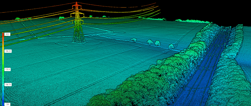
Managing and monitoring environmental and wildlife areas present unique challenges, including the need for non-intrusive methods, ensuring environmental compliance, and accessing hard-to-reach areas. Traditional survey techniques can be disruptive, time-consuming, and expensive.

Additionally, monitoring large or protected areas, such as wetlands or conservation zones, requires methods that do not disturb sensitive ecosystems.

Advanced Survey Technology for Environmental & Wildlife Monitoring

We utilise a range of advanced technologies, including drones, LiDAR, and remote sensors, to deliver accurate environmental data without disturbing the natural habitat.

These technologies provide real-time monitoring of landscape changes, such as bank erosion, and allow for the non-intrusive surveying of wildlife populations.

Our drone surveys cover large areas quickly and cost-effectively, ensuring that we capture essential data while reducing environmental impact.

Drone Survey Matrix Consulting Engineers

Services for Environmental & Wildlife Surveys

Environmental Monitoring

Offering accurate, real-time monitoring solutions to assess environmental conditions and ensure compliance with regulatory standards.

Drone Survey

Providing high-precision aerial surveys using advanced drone technology to deliver detailed imagery and data for a wide range of projects.

Topographical
Survey

Creating accurate maps and 3D models of land features to support planning, engineering, and design projects.

Why Choose Us for Environmental & Wildlife Surveys?

At Matrix Advanced Surveying, we combine years of industry experience with cutting-edge drone technology to provide property managers with reliable and efficient survey solutions. Our services offer comprehensive insights, reduce operational costs, and improve safety.

We are committed to delivering results that help property managers maintain, develop, and protect their assets with precision and professionalism. Trust us to provide accurate and timely data, every time.

READY TO START YOUR NEW PROJECT?

We invite you to discover the difference that Matrix Advanced Surveying can make for your project. Contact us today to learn more about our services and how we can help you navigate the complexities of modern surveying with confidence and expertise.

Contact Form